Trails in the Orotava Valley
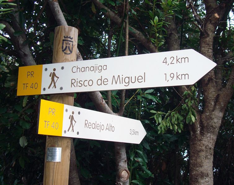
PR - TF 40 Hillside of Tigaiga
To keep in mind
This is a high-difficulty trail, due to its length and large drops. For a shorter option follow the trial PR-TF 40.1 Camino Punta del Risco. If you decide to take the Camino del Guarda stretch, bear in mind that landslides may occur.
Getting there
Access to Realejo Alto: Road TF - 342, km 0.1
Access to the Chanajiga Recreational Area: Detour at km 5.6 on road TF-326
Description of the route
The trail begins in the Santiago Apóstol church square in Realejo Alto (municipality of Los Realejos) following the La Lora Ravine stretch. From there, it ascends through stretches of monteverde forest, passing through the lush Til de Los Pavos, until reaching the Chanajiga Recreational Area. The trail continues through the delightful Camino del Guarda reaching the El Asomadero lookout point, going down to the La Lora Ravine. From this point, it follows the initial stretch until reaching the Santiago Apóstol square.
PR - TF 40.1 Camino Punta del Risco
To keep in mind
To reach this trail you need to follow a stretch of PR-TF 40 Camino Punta del Risco beforehand, from Realejo Alto or from the Chanajiga Recreational Area. This combination will enable you to follow a shorter and less difficult circular route than the PR-TF 40 Camino Punta del Risco trail in its entirety.
Getting there
Access to Realejo Alto: Road TF - 342, km 0.1
Access to the Chanajiga Recreational Area: Detour at km 5.6 on road TF-326
Connection with other trails: PR-TF 40
Description of the route
If you follow the PR-TF 40 Camino Punta del Risco trail from Realejo Alto (municipality of El Realejo), you will come across the beginning of this
short alternative at the crossroads between the La Calera Ravine and Camino de Las Traviesas. From there, it ascends the hillside continuously and at a gentle slope, passing through a rich monteverde forest. Finally, it reaches PR-TF 40 Camino Punta del Risco on the Pino Llorón track at a point known as Punta del Risco.
AGUAMANSA - LA CALDERA - CHIMOCHE
You set out from Aguamansa and follow the camino del Bosquete to the Benijos forestry track. You cross the main road and take the La Caldera turning, walking through an area pine forest with abundant wax myrtle and tree heath.
You go around La Caldera crater and take the Chimoche road as far as the water gallery. You then continue climbing up to Chimoche. Following the forestry track, you will come to the Bermeja hut, with a picnic area, and you can then go back down to La Caldera, through pines and broom and pick up the path to Aguamansa.
This trail takes about three hours.
BUS: 345 (Titsa Bus company) from Puerto de la Cruz to Aguamansa and La Caldera, via La Orotava.
AGUAMANSA - ANTONIO LUGO - BENIJOS
From the Aguamansa forestry station, you take the camino del Bosquete, which takes you to the Benijos forestry track. Around Monteverde, you go past La Fortuita water gallery. Beyond the Mataznos ravine the pine forest starts. Crossing the Pino Soler gallery takes you to the Antonio Lugo hut.
If you go north down hill, you come out of the forest by some farms and the Benijos road, where you can catch Titsa bus number 347 to La Orotava or Los Realejos. The alternative is to go back to the hamlet of Chasna, along the main road to La Orotava, and catch bus number 345, which runs between La Orotava and Puerto de la Cruz.
This walk takes about four hours.
AGUAMANSA - LA FLORIDA - SANTA ÚRSULA
You go downhill from Aguamansa toward the hamlet and turn off toward the Mamio muntain where it says El Velo, crossing some gullies and farmland, dotted with chestnut trees. You follow the old peaks trail to the village of Pinoleris. You take the track toward Cuatro Cantillos, opposite the church, down to La Florida, a district of La Orotava full of tradition, folklore and crafts.
At La Palma, you take the Pino Alto track, climbing up beyond Mestre Juan and La Resbala. The view over the Orotava Valley from Pino Alto onwards is unique.
From here, you follow the La Corujera road, descending to La Cuesta de la Villa, where you can catch bus number 101 that runs between La Orotava and Puerto de la Cruz.
This walk takes about four hours.
AGUAMANSA - ALMADI - PINO ALTO - CAFÉ HUMBOLDT
You can start this route in La Caldera, taking the forestry track to Los Organos, or from the Aguamansa forestry station, down towards El Velo and on to the Pérez Ventoso hut.
Following the old peaks trail, through tree heath and pine trees to El Topo, and the forestry track that winds along to the Almadi hut at 1,450 m. above sea level. The view of the forest, the whole valley and Teide from here is incredible.
From here, the trail descends along the valley ridge to the hamlet of Pino Alto, beyond the forest. You then go downhill towards La Florida and, when you get to Mestre Juan, you take the camino de la Charca to the Café Humboldt on the main North road. From here, you can catch bus number 101 to La Orotava and Puerto de la Cruz.
This walk takes about six hours.
EL SAUCE - FUENTE VIEJA - EL BREZAL - PALO BLANCO
From the El Sauce bend, at Km 7.500 along the La Orotava - Las Cañadas del Teide road, there is a track leading off - La Ladera - that crosses the Montijo, La Perdoma and Cruz Santa highlands at about 600 m. It crosses potato fields, orchards and vines, going up and down gullies to Fuente Vieja, from where you can either climb up to Benijos or go down to La Perdoma, or you can even carry on to the Brezal track and descend to Cruz Santa from there, or climb up to Las Llanadas and finish at Palo Blanco, from where you can catch bus number 347, which runs between Los Realejos and La Orotava.
This walk takes about three hours.
LOS REALEJOS- LA RAMBLA - LA GUANCHA
From Los Realejos, where Viera y Clavijo was born, you climb up to the hamlet of Tigaiga, at the foot of the slopes. Further up, you come to Icod el Alto, with some amazing views over the Orotava Valley. If you continue up the slope, you will get to the La Corona look out, with more spectacular views over the valley.
To the west is La Guancha, a farming and handicraft village with top quality white wine, potatoes and fruit. There is a recreation area and camp site in the pine forest., called El Lagar and Los Llanos de Arena.
On the way back, you take the forestry track to the Los Realejos forestry station and then down the hillside to El Lance, Icod El Alto or Madrejuana.
From the main road, you can catch bus number 354 back to Puerto de la Cruz.
The time taken for this walk depends on the route you choose.
Trails on the Tigaiga slopes
La Madrejuana - La Corona (30 minutes)
It starts from the hamlet of La Madrejuana, winding through farmlands and vegetation of wax myrtle and tree heath, to the La Corona look out at 780 m. above sea level.
La Corona - La Fortaleza - Pico de Teide (8 hours)
This is one of the most popular trails in Tenerife. It starts from La Corona lookout point and goes along the whole Ladera de Tigaiga flank. From La Fortaleza, there is a spectacular view of Teide.
Barranco Ruiz - Risco de las Pencas (1 hour)
This trail, built by the Island Cabildo (government) sets out from the Barranco Ruíz recreation area and runs along the right side of the gully in the Borough of San Juan de la Rambla.
El Madroño - Risco de Miguel (45 minutes)
This is a recently built trail that sets out from the Madroño track, crosses the Furnia gully and climbs a steep slope to the Chanajiga track at Risco de Miguel.
Chanajiga - Piedra de los Pastores (1 hour)
This sets out from the Chanjjga recreation area, passing the Zarza gallery and crosses the Almagre track and takes you to Piedra de los Pastores on the Ladera de Tigaiga flank.
Tigaiga - Vueltas de Icod el Alto - Risco Blanco (30 minutes)
This is one of the most historic trails in Los Realejos. It starts from Cruz del Aserradero, in Tigaiga, going through Los Pinitos and through the hairpins until it reaches Risco Blanco on the Icod el Alto road.
Choza Sventenius - Piedra de los Pastores - Icod el Alto
This route starts at kilometre 29,200, on the TF-21 that goes from La Orotava to Las Cañadas del Teide, where the Sventenius hut (Choza in Spanish) is, in the Borough of Los Realejos. You can take bus number 348 from Puerto de la Cruz to the starting point near El Portillo turnoff.
You take the forestry track that sets out from the Sventenius hut to the Piedra de los Pastores lookout point, where you get a marvellous view over the valley. The track takes you through pine forests, descending the ridge line of the peaks, to the Viera y Clavijo hut. About 200 m. along the track, you come to the Roque Miguel lookout. From here, you follow the ridge line and, without loosing sight of the valley, you get to La Corona look out, after travelling through fruit orchards and potato fields. This look out is situated at about 800 m. above sea level, and acts as a balcony over Los Realejos, with superb views over the north of the island. If you follow the road, you come to Icod el Alto, from where you can catch bus number 345 to Los Realejos and Puerto de la Cruz.
This walk takes about five hours.
Walks on the coast
Puerto de la Cruz - El Bollullo - El Rincón
From Martiánez beach or from La Paz to go east to the coastal path (Camino de la Costa). Past the Martiánez road, you descend to the gully and soon you are in the borough of La Orotava, where we can look over El Bollullo beach, with a lovely view from the cliffs. From here there is a path that takes you down to the beach itself.
There is a restaurant on the beach and, if you carry on heading east, you come to the beaches of Ancón and Los Patos.
You can return via El Rincón, where you can pick up a bus that runs between San Diego and La Orotava (not very frequent), or you can go up the track that will take you to Cuesta de la Villa, although the last part is quite steep. If you take the latter alternative, the whole walk takes about three hours.
You can also come back to Puerto de la Cruz along the same route you came along.
Sendero del Agua (the water trail)
This trail is called the water trail because it crosses old water channels and passes springs. It starts from Acapulco apartments, behind the Hotel Maritím. It runs along the Playa de los Roques cliffs. The beach is so-called because of the three rocks (Grande, Chico and La Patita). In this area, you cans see plant species like sea parsley, cactus spurge, common spurge, tamarisk and some cultivated terraces.
The path continues through the resort of Romantica II, along Calle Amapolas, Calle Palmeras and Calle Rosas. You then take the Llanos de Mendez fork to the Campo Santo lookout.
A few minutes later, you come to Romantica I, from where you get a wonderful view of the cliffs, Playa de la Fajana and the ruins of the Gordejuela water lift. 320 steps lead down to the beach. After the Gordejuela water lift, you start to climb to pick up the path again that will take you to Rambla de Castro, an area of the coast of Los Realejos that has been declared a protected natural area, with two interesting historic buildings: La Casona de los Castro (The Castro Mansion) and the Fortín de San Fernando (San Fernando Fort).